 |
Dr. Robert Chambers elaborates on Participatory GIS (PGIS) practice
Duration: 7:33
Recommended for use in: M01, M05, M06 |
| Robert Chambers from the Institute of Development Studies (IDS), UK, reflects on participatory development and Geographic Information Systems (GIS) and the resulting good and bad practices. In the interview, Robert calls on practitioners and development agencies to ensure that good practice is put in place to avoid repeating the misuse of Participatory Rural Appraisal that occurred in the 1980s and 1990s. ... more.
|
 |
Participatory 3D Modelling: a review
Duration: 5:26
Recommended for use in: M10 |
| Giacomo Rambaldi from the Technical Centre for Agricultural and Rural Co-operation (CTA), Netherlands, talks about his involvement in the improvement, development, promotion and dissemination of a participatory mapping method known as Participatory 3D Modelling (P3DM). P3DM is a community-based mapping method which integrates local spatial knowledge with data on land elevation and sea depth to produce stand-alone, scaled and geo-referenced relief models. Informants depict land use and cover, and other features on the model by using pushpins (points), yarn (lines) and paint (polygons). Once the model is completed, a scaled and geo-referenced grid is applied to enable data to be extracted, digitised and plotted. The model remains with the community. ... more.
|
 |
Dave De Vera Elaborates on Participatory GIS Practice in the Philippines
Duration: 7:23
Recommended for use in: M02, M10 |
| Dave De Vera is the Executive Director of the Philippine Association for Intercultural Development (PAFID). In his interview Dave elaborates on the use of Participatory Geographic Information Systems (PGIS) practice in the Philippines to support indigenous communities in filing ancestral land claims. He describes the mapping methods used, explains why Participatory 3D Modelling (P3DM) is the most effective method, and highlights the need for local ownership of the process, competency of the technology intermediary, quality work, and constructive relationships with the government. Dave gives examples of PAFID-government partnerships and analyses the pillars of legitimisation process. ... more.
|
 |
Peter Poole reports on his experience with community mapping
Duration: 9:59
Recommended for use in: M09 |
| In this interview, Peter Poole, Director of Local Earth Observation (LEO), Netherlands, traces the evolution of a map-making methodology which began with the introduction of Global Positioning System (GPS) to the Inuits in 1989 and evolved throughout the 1990s in a series of projects in the Amazon, the Arctic and Asia. Tenure maps depict indigenous names, resources and special places on scaled maps, intended as evidence in negotiating processes. Peter describes the search for an inexpensive, simple, appropriate geomatic technology. Community-based teams would gather raw field data, and indigenous associations or support non-governmental organisations set up mapping units to serve the field teams. Three lessons are described: (i) communities can make their own scaled maps; (ii) emerging mapping centres should make their services accessible to all communities; and (iii) the methodology not only produces a tenure map, but also equips and inspires community mappers to diversify their skills in environmental information management. ... more.
|
 |
Interview with Dr. Mike McCall on training in Participatory GIS practice
Duration: 8:03
Recommended for use in: M03 |
| In this interview, Michael McCall from Faculty of Geo-Information Science and Earth Observation of the University of Twente, Netherlands, argues that there is clearly a demand for capacity building in Participatory Geographic Information Systems (PGIS). Communities value it for claiming lands, managing resources, resolving conflicts, and recording their cultural landscapes. Training institutions understand this demand through intermediaries such as community-based organisations and local schools. PGIS is at a strong juncture because hardware and software are progressing quickly in terms of availability, user-friendliness and transparency. However, training is not merely a matter of technology, but of exchanging ideas amongst users and trainers on effective and acceptable applications. The challenges facing PGIS are not unique: Who in the community participates in mapping? Who chooses the participants? New information is generated and may be disseminated into the public domain, but some are reluctant to share it for good reasons. Thus, the heart of the PGIS ethic is: Who controls, and who is sharing? ... more.
|
 |
Interview with Steve deRoy about the role of networking and communication in PGIS practice
Duration: 3:55
Recommended for use in: M15 |
| In this interview, Steven DeRoy, Research Associate/GIS Specialist, Centre for Indigenous Environmental Resources (CIER), Canada, describes the power of networking and the importance of integrating this practice into the daily realm of Participatory Geographic Information Systems (PGIS). These professional exchanges create an opportunity for practitioners to share ideas and approaches to solve common challenges. Maps also play a vital role in communicating ideas amongst different parties and for advocating change in current affairs. ... more.
|
 |
Knowledge and Cultural Transmission in Kenyan Participatory Mapping
Duration: 4:37
Recommended for use in: M10, M15 |
| In this five-minute interview, Dr. Nigel Crawhall, Director of Secretariat at the Indigenous Peoples of Africa Coordinating Committee (IPACC), a pan-African network, elaborates on intergenerational ecological knowledge transmission in participatory three-dimensional modelling (P3DM). Crawhall discusses his observations on intergenerational interaction when the Ogiek community of Nessuit, Kenya built a geo-referenced model of their mountain forest landscape in 2006. ... more.
|
 |
Interview with Mr. Kenn Mondiai from Partners with Melanesians
Duration: 4:36
Recommended for use in: M01, M05 |
| Kenn Mondiai, Executive Director of "Partners with Melanesians", a non-governmental organisation based in Papua New Guinea, reports on the importance of adopting sound Participatory Geographic Information Systems (PGIS) practices in his country. He comments on the fact that forest management in Papua New Guinea is quite a controversial issue and tends to be extractive and unsustainable. The non-governmental organisation for which Kenn is working is planning to move from using conventional Geographic Information Systems to more inclusive methods like Participatory 3D Modelling, which he came to know in Fiji. Kenn further explains the reasons behind his new vision, including the need for integrating local knowledge into planning processes and maximising grassroots participation at all stages of project implementation. ... more.
|
 |
Supporting Participatory GIS use in community measurement and monitoring of carbon for reduced emissions from deforestation and forest degradation (REDD) purposes
Duration: 4:26
Recommended for use in: M06 |
| In this interview, Peter Minang, Global Coordinator, ASB Partnership for Tropical Forest Margins, World Agroforestry Centre (ICRAF), Kenya, discusses issues related to the use of Participatory Geographic Information Systems (PGIS) in the context of planning, measurement, monitoring and reporting carbon at the community level. In terms of introducing and supporting PGIS adoption, he highlights that the following need to be taken into account: (i) minimum literacy and numeracy of participants (completed primary school); (ii) community resources and ability to afford basic equipment such as a Global Positioning System (GPS) and forest inventory equipment; and (iii) the need for basic training in conducting forests inventories and using geospatial tools. In terms of ensuring sustained use of PGIS tools within the community, Peter calls attention to the need to raise awareness on existing carbon financing options such as the clean development mechanism. The latter could be tapped to cover the costs of procurement and maintenance of equipment, long-term operations, institutional capacity building and some institutional support in terms of establishing procedures. ... more.
|
 |
Holly Ashley discusses PLA special issue on PGIS practice
Duration: 3:30
Recommended for use in: M01 |
| In this interview, Holly Ashley, co-editor of Participatory Learning and Action (PLA), an informal journal published by the International Institute for Environment and Development (IIED) in the UK, discusses plans to publish a special issue of PLA on PGIS practice. She focuses on how the issue plans to promote the spread of good practice through the use of participatory approaches. PLA 54 "Mapping for Change: practice, technologies and communication" was published by IIED and CTA in 2006. In 2007, the issue was translated into 12 languages and republished in electronic format on DVD. ... more.
|
 |
Silika Tuivanuavou shares her experience in practicing P3DM in Fiji
Duration: 2:26
Recommended for use in: M10 |
| Silika Tuivanuavou is the Spatial Information Coordinator at the Native Land Trust Board in Suva, Fiji Islands. In this interview Silika shares her opinions in using Participatory 3D Modelling for land use planning and bottom-up communication purposes. ... more.
|
 |
The Convention for the Safeguarding of the Intangible Cultural Heritage and PGIS practice
Duration: 2:00
Recommended for use in: M05 |
| Reiko Yoshida, Assistant Programme Specialist, Intangible Heritage Section at UNESCO, France, elaborates on the relevance of the Convention on the Safeguarding of Intangible Cultural Heritage during the Mapping for Change Conference, which took place in Nairobi, Kenya in September 2005. In her interview Reiko anticipates that once the convention is ratified a fund will be set up. Inventorying intangible cultural heritage is one of the areas the fund will cover, and where Participatory Geographic Information Systems (PGIS) practitioners could seek support. ... more.
|
 |
Maps are an Important Means for Bottom-up Communication and Self-assertion
Duration: 3:27
Recommended for use in: M01 |
| Giacomo Rambaldi, Senior Programme Coordinator at the Technical Centre for Agricultural and Rural Cooperation ACP-EU (CTA), elaborates on the role of PGIS practice in rural development. In his view, participatory mapping offers opportunities for ordinary people to have a more authoritative say on how to administer the territories they occupy and use. The use of geographic information technologies coupled with the visual, easily understood language of maps enables those at the grassroots level to entertain peer to peer dialogues with higher authorities. Rambaldi argues that being on a map corresponds with existing, and with being in the position to make one’s voice heard and to negotiate access to services and utilities, which is so important in rural settings. ... more.
|
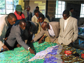 |
Ogiek Indigenous People Mapping Their Lands in Kenya
Duration: 3:38
Recommended for use in: M10 |
| Julius Muchemi, Executive Director of ERMIS Africa, an NGO based in Kenya, reports on a participatory 3D modelling exercise which occurred in Nessuit, Kenya in August 2006. In the course of the exercise – attended by representatives from 21 Ogiek clans – an area of 52,800 ha was mapped at a 1:10,000 scale. Participants included close to 120 representatives from the different clans, including men and women. Elders populated the model with their memories dating back to 1925 and reconstructed the landscape as it was at that time. The model displays 64 data layers including different types of areas, points and lines. In 2008, the Ogiek people expanded the coverage of the model to include an additional 40,000 ha. ... more.
|
 |
Ethics are Central to Community-based Mapping Processes
Duration: 1:57
Recommended for use in: M02 |
| Dr. Nigel Crawhall, Director of Secretariat at the Indigenous Peoples of Africa Coordinating Committee (IPACC), a pan-African network, elaborates on the value of ethics in the context of participatory mapping processes. ... more.
|