 |
Localisation, Participation and Communication: an Introduction to Good PGIS Practice
Duration: 15:00
Recommended for use in: M01, M06 |
| The practice of participatory geospatial information management and communication is increasing in popularity. It is used to help indigenous, marginalised, and other groups of people to support change based on their own needs. It provides many actors in society a powerful blend of practice and technology. Nonetheless, with its practice comes the need for responsible planning and use. This video is an introduction to a Training Kit published by CTA and IFAD to support the spread of good practice in generating, managing, analysing and communicating spatial information. ... more.
|
 |
Geographic Information Technology, CyberTracker and Local Spatial Knowledge
Duration: 2:44
Recommended for use in: M01, M09 |
| Louis Liebenberg, founder and developer of CyberTracker technology, shares his views on the importance of maintaining local knowledge and on being aware that technology may seduce users at the cost of disempowering local knowledge holders. Liebenberg further highlights the role of the "Training Kit on Participatory Spatial Information Management and Communication" in empowering grassroots activities. ... more.
|
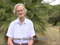 |
Dr. Robert Chambers elaborates on Participatory GIS (PGIS) practice
Duration: 7:33
Recommended for use in: M01, M05, M06 |
| Robert Chambers from the Institute of Development Studies (IDS), UK, reflects on participatory development and Geographic Information Systems (GIS) and the resulting good and bad practices. In the interview, Robert calls on practitioners and development agencies to ensure that good practice is put in place to avoid repeating the misuse of Participatory Rural Appraisal that occurred in the 1980s and 1990s. ... more.
|
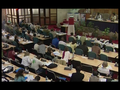 |
Mapping for Change 2005: Report Back
Duration: 13:41
Recommended for use in: M01, M06 |
| A 13-minute reportage on the Mapping for Change Conference which took place in Nairobi, Kenya on 7-10 September 2005. The reportage features interviews with practitioners from around the globe and summarises the process and outcomes of the event. A total of 154 participants from 45 countries including Indigenous and First Nations people shared their experiences. Working groups responding to specific tasks brought participants together to engage in collaborative learning on issues including: (i) enabling and disabling environments; (ii) sharing experiences on ways of representing local spatial knowledge, claiming land and managing resources, issues related to participatory process, and ideas on how to support the safeguarding of cultural heritage; and (iii) building a common vision among Participatory Geographic Information Systems (PGIS) practitioners. The event included the development of a way forward for enhancing networking and communication, drafting regional strategies for supporting the practice, and promoting it vis-à-vis donors and international development agencies. ... more.
|
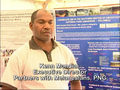 |
Interview with Mr. Kenn Mondiai from Partners with Melanesians
Duration: 4:36
Recommended for use in: M01, M05 |
| Kenn Mondiai, Executive Director of "Partners with Melanesians", a non-governmental organisation based in Papua New Guinea, reports on the importance of adopting sound Participatory Geographic Information Systems (PGIS) practices in his country. He comments on the fact that forest management in Papua New Guinea is quite a controversial issue and tends to be extractive and unsustainable. The non-governmental organisation for which Kenn is working is planning to move from using conventional Geographic Information Systems to more inclusive methods like Participatory 3D Modelling, which he came to know in Fiji. Kenn further explains the reasons behind his new vision, including the need for integrating local knowledge into planning processes and maximising grassroots participation at all stages of project implementation. ... more.
|
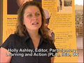 |
Holly Ashley discusses PLA special issue on PGIS practice
Duration: 3:30
Recommended for use in: M01 |
| In this interview, Holly Ashley, co-editor of Participatory Learning and Action (PLA), an informal journal published by the International Institute for Environment and Development (IIED) in the UK, discusses plans to publish a special issue of PLA on PGIS practice. She focuses on how the issue plans to promote the spread of good practice through the use of participatory approaches. PLA 54 "Mapping for Change: practice, technologies and communication" was published by IIED and CTA in 2006. In 2007, the issue was translated into 12 languages and republished in electronic format on DVD. ... more.
|
 |
Maps are an Important Means for Bottom-up Communication and Self-assertion
Duration: 3:27
Recommended for use in: M01 |
| Giacomo Rambaldi, Senior Programme Coordinator at the Technical Centre for Agricultural and Rural Cooperation ACP-EU (CTA), elaborates on the role of PGIS practice in rural development. In his view, participatory mapping offers opportunities for ordinary people to have a more authoritative say on how to administer the territories they occupy and use. The use of geographic information technologies coupled with the visual, easily understood language of maps enables those at the grassroots level to entertain peer to peer dialogues with higher authorities. Rambaldi argues that being on a map corresponds with existing, and with being in the position to make one’s voice heard and to negotiate access to services and utilities, which is so important in rural settings. ... more.
|
 |
Introduction to the Training Kit on Participatory Spatial Information Management and Communication
Duration: 2:16
Recommended for use in: M01 |
| Dr. Nigel Crawhall, Director of Secretariat at the Indigenous Peoples of Africa Coordinating Committee (IPACC), a pan-African network, introduces the Training Kit on Participatory Spatial Information Management and Communication and its value in promoting good practice and adding authority to local knowledge. ... more.
|
 |
The Training Kit on Participatory Spatial Information Management and Communication and Its Objectives
Duration: 1:56
Recommended for use in: M01 |
| Giacomo Rambaldi, Senior Programme Coordinator at the Technical Centre for Agricultural and Rural Cooperation ACP-EU (CTA), introduces the Training Kit on Participatory Spatial Information Management and Communication produced by CTA, the International Fund for Agricultural Development (IFAD) and other development partners. ... more.
|