 |
Localisation, Participation and Communication: an Introduction to Good PGIS Practice
Duration: 15:00
Recommended for use in: M01, M06 |
| The practice of participatory geospatial information management and communication is increasing in popularity. It is used to help indigenous, marginalised, and other groups of people to support change based on their own needs. It provides many actors in society a powerful blend of practice and technology. Nonetheless, with its practice comes the need for responsible planning and use. This video is an introduction to a Training Kit published by CTA and IFAD to support the spread of good practice in generating, managing, analysing and communicating spatial information. ... more.
|
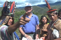 |
RROMUEPATSRO: Mapping the Historical-Cultural Space of the Yanesha, Perú
Duration: 9:22
Recommended for use in: M06 |
| This video is the first in a series titled "Where Our Ancestors Walked: Mapping the Historical-Cultural Space of the Yanesha People," which was made in collaboration with the Yanesha people in order to preserve their history and its relation with their territory as sacred landscape. Rromuepatsro presents the Yanesha people, located in the eastern slope of the Peruvian central Andes, and explores their vital relationship with their ancestors and the natural landscape. It shows how they have used PGIS, anthropological research and Yanesha oral history to map their historical cultural space and thus reaffirm their millennial link to the ancient world and the civilisation of the central Andes. ... more.
|
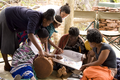 |
Reviving Our Culture, Mapping Our Future
Duration: 12:40
Recommended for use in: M06, M08, M15 |
| This video tells the story of a special gathering in Venda, South Africa and a community process in eco-cultural mapping. Indigenous leaders from Altai (Russia) and the Colombian Amazon and NGO representatives from Ethiopia, Kenya and South Africa accompany the Tshidvizhe community as they explore a simple yet powerful way to express the past and present of their territory and livelihoods onto hand-drawn maps. The maps highlight the importance of their culture, sacred sites and territory, and empower them to map the future towards which they need to strive.
Production: The Gaia Foundation, African Biodiversity Network, Mupo Foundation and the Technical Centre for Agricultural and Rural Co-operation ACP-EU (CTA). ... more.
|
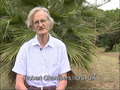 |
Dr. Robert Chambers elaborates on Participatory GIS (PGIS) practice
Duration: 7:33
Recommended for use in: M01, M05, M06 |
| Robert Chambers from the Institute of Development Studies (IDS), UK, reflects on participatory development and Geographic Information Systems (GIS) and the resulting good and bad practices. In the interview, Robert calls on practitioners and development agencies to ensure that good practice is put in place to avoid repeating the misuse of Participatory Rural Appraisal that occurred in the 1980s and 1990s. ... more.
|
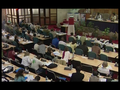 |
Mapping for Change 2005: Report Back
Duration: 13:41
Recommended for use in: M01, M06 |
| A 13-minute reportage on the Mapping for Change Conference which took place in Nairobi, Kenya on 7-10 September 2005. The reportage features interviews with practitioners from around the globe and summarises the process and outcomes of the event. A total of 154 participants from 45 countries including Indigenous and First Nations people shared their experiences. Working groups responding to specific tasks brought participants together to engage in collaborative learning on issues including: (i) enabling and disabling environments; (ii) sharing experiences on ways of representing local spatial knowledge, claiming land and managing resources, issues related to participatory process, and ideas on how to support the safeguarding of cultural heritage; and (iii) building a common vision among Participatory Geographic Information Systems (PGIS) practitioners. The event included the development of a way forward for enhancing networking and communication, drafting regional strategies for supporting the practice, and promoting it vis-à-vis donors and international development agencies. ... more.
|
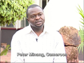 |
Supporting Participatory GIS use in community measurement and monitoring of carbon for reduced emissions from deforestation and forest degradation (REDD) purposes
Duration: 4:26
Recommended for use in: M06 |
| In this interview, Peter Minang, Global Coordinator, ASB Partnership for Tropical Forest Margins, World Agroforestry Centre (ICRAF), Kenya, discusses issues related to the use of Participatory Geographic Information Systems (PGIS) in the context of planning, measurement, monitoring and reporting carbon at the community level. In terms of introducing and supporting PGIS adoption, he highlights that the following need to be taken into account: (i) minimum literacy and numeracy of participants (completed primary school); (ii) community resources and ability to afford basic equipment such as a Global Positioning System (GPS) and forest inventory equipment; and (iii) the need for basic training in conducting forests inventories and using geospatial tools. In terms of ensuring sustained use of PGIS tools within the community, Peter calls attention to the need to raise awareness on existing carbon financing options such as the clean development mechanism. The latter could be tapped to cover the costs of procurement and maintenance of equipment, long-term operations, institutional capacity building and some institutional support in terms of establishing procedures. ... more.
|