 |
Giving Voice to the Unspoken
Duration: 22:35
Recommended for use in: M10 |
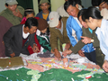
| This 21-minute video produced in 2001 shows the hands-on aspects of Participatory 3D Modelling (P3DM). The video supports all practical aspects of P3DM described in the resource book "Participatory 3-Dimensional Modelling: Guiding Principles and Applications" and documents in detail an exercise conducted within the Pu Mat National Park, a protected area in Vietnam. The video provides background on the development of a method in South-east Asia in the mid 1990s as a complement to technology-depended Geographic Information Systems (GIS) and offers visual guidance on how to assemble participatory 3-dimensional models at village level. It also explains the strengths, weaknesses and opportunities of the model. ... more.
|
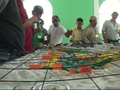 |
Lessons learned in constructing a participatory 3D model in Telpaneca, Nicaragua
Duration: 8:52
Recommended for use in: M10 |
| This video discusses the construction of a 3D model in a rural area. It is based on an experience that took place with the indigenous peoples in the territories of Telpaneca in Nicaragua. ... more.
|
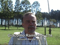 |
Participatory 3D Modelling: a review
Duration: 5:26
Recommended for use in: M10 |
| Giacomo Rambaldi from the Technical Centre for Agricultural and Rural Co-operation (CTA), Netherlands, talks about his involvement in the improvement, development, promotion and dissemination of a participatory mapping method known as Participatory 3D Modelling (P3DM). P3DM is a community-based mapping method which integrates local spatial knowledge with data on land elevation and sea depth to produce stand-alone, scaled and geo-referenced relief models. Informants depict land use and cover, and other features on the model by using pushpins (points), yarn (lines) and paint (polygons). Once the model is completed, a scaled and geo-referenced grid is applied to enable data to be extracted, digitised and plotted. The model remains with the community. ... more.
|
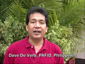 |
Dave De Vera Elaborates on Participatory GIS Practice in the Philippines
Duration: 7:23
Recommended for use in: M02, M10 |
| Dave De Vera is the Executive Director of the Philippine Association for Intercultural Development (PAFID). In his interview Dave elaborates on the use of Participatory Geographic Information Systems (PGIS) practice in the Philippines to support indigenous communities in filing ancestral land claims. He describes the mapping methods used, explains why Participatory 3D Modelling (P3DM) is the most effective method, and highlights the need for local ownership of the process, competency of the technology intermediary, quality work, and constructive relationships with the government. Dave gives examples of PAFID-government partnerships and analyses the pillars of legitimisation process. ... more.
|
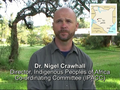 |
Knowledge and Cultural Transmission in Kenyan Participatory Mapping
Duration: 4:37
Recommended for use in: M10, M15 |
| In this five-minute interview, Dr. Nigel Crawhall, Director of Secretariat at the Indigenous Peoples of Africa Coordinating Committee (IPACC), a pan-African network, elaborates on intergenerational ecological knowledge transmission in participatory three-dimensional modelling (P3DM). Crawhall discusses his observations on intergenerational interaction when the Ogiek community of Nessuit, Kenya built a geo-referenced model of their mountain forest landscape in 2006. ... more.
|
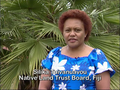 |
Silika Tuivanuavou shares her experience in practicing P3DM in Fiji
Duration: 2:26
Recommended for use in: M10 |
| Silika Tuivanuavou is the Spatial Information Coordinator at the Native Land Trust Board in Suva, Fiji Islands. In this interview Silika shares her opinions in using Participatory 3D Modelling for land use planning and bottom-up communication purposes. ... more.
|
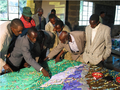 |
Ogiek Indigenous People Mapping Their Lands in Kenya
Duration: 3:38
Recommended for use in: M10 |
| Julius Muchemi, Executive Director of ERMIS Africa, an NGO based in Kenya, reports on a participatory 3D modelling exercise which occurred in Nessuit, Kenya in August 2006. In the course of the exercise – attended by representatives from 21 Ogiek clans – an area of 52,800 ha was mapped at a 1:10,000 scale. Participants included close to 120 representatives from the different clans, including men and women. Elders populated the model with their memories dating back to 1925 and reconstructed the landscape as it was at that time. The model displays 64 data layers including different types of areas, points and lines. In 2008, the Ogiek people expanded the coverage of the model to include an additional 40,000 ha. ... more.
|
 |
Digitising Vector Data
Duration: 10:20
Recommended for use in: M10U04, M12 |
| Learn how to create and edit vector and attribute data. In the previous two videos the producer discussed vector data namely geometry and attributes. The geometry of a vector feature describes its shape and position, while the attributes of a vector feature describe its properties (e.g. colour, size, age). This video describes the process of creating and editing vector data – both the geometry and attributes of vector features. ... more.
|