
Title: Spatial Analysis: Vector Data
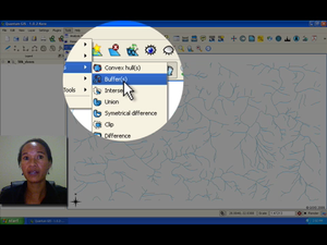
Summary: Understand the use of buffering in vector spatial analysis. Spatial analysis uses spatial information to extract new and additional meaning. Usually spatial analysis is carried out using a GIS application. A GIS normally has spatial analysis tools for feature statistics (e.g. how many vertices make up this polyline?) or geo-processing, such as feature buffering (e.g. which area falls within a certain distance of this feature?). This video looks more closely at vector analysis, using buffering as an example.
Producer: Chief Directorate: Spatial Planning & Information, Department of Land Affairs, Eastern Cape, South Africa
Director: Tim Sutton
Source language: English; Subtitles: none
Genre: Tutorial
Duration: 8:34
License: Attribution-Noncommercial-No Derivative Works 3.0 Unported
Recommended for use in Module(s): M12
File Format: mov
Note: This video production is available on Disk No. 2
